
Shoreline Resilience and Inlet Management
Principal Investigators
Steve Elgar, Woods Hole Oceanographic Institution
Britt Raubenheimer, Woods Hole Oceanographic Institution
Paige Hovenga, Woods Hole Oceanographic Institution

Summary
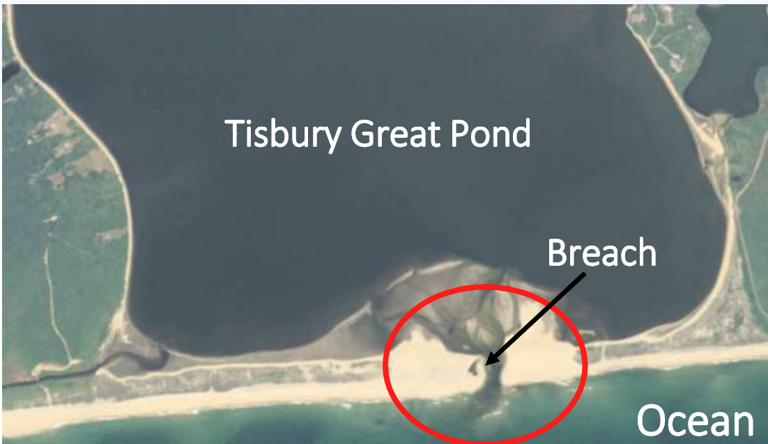
We are investigating the resilience of sandy shorelines, and in particular the evolution and subsequent recovery of beaches after inlet breaching. Many coastal ponds on Cape Cod, Martha’s Vineyard, Nantucket, and mainland Massachusetts shorelines are drained intentionally (“breached”) to lower pond water levels that threaten homes, to promote healthy habitats, and to facilitate migration of marine species. However, often breaches close before tidal flushing has had sufficient time for nutrient goals to be reached. For example, the breach of Sesachacha Pond, Nantucket (Fig. 1, and this video) can close in as little as 24 hours after it is opened, preventing significant exchange with the ocean and frustrating local efforts to improve habitat.
Although numerical models accurately simulate storm-induced erosion, allowing coastal engineers and managers to make predictions and plan accordingly, the slower recovery of the shoreline is not well understood. The several-times yearly breachings of Sesachacha Pond (Fig. 1) and Tisbury Great Pond (Fig. 2) provide a unique opportunity to observe and develop models for the recovery of beaches and the corresponding closing of ponds after inlet breaching. We are using existing observations and new model simulations to (1) determine the causes of beach recovery after storms or inlet openings and (2) develop breaching strategies that optimize exchange between coastal ponds and the ocean for a range of ponds and barrier beaches, as well as a range of wind, tidal, and wave conditions. Our objective is to explore the recovery of beaches after they have been disturbed to determine the best approaches (e.g., inlet geometry, tide stage, wave and wind conditions) for machine-made breaches at different locations. Additionally, we aim to improve understanding of sediment transport mechanisms so that numerical modeling systems can be developed to simulate the evolution of complex sandy shorelines.

Expected Outcomes
We share the results of our Sea Grant supported research with The Trustees of Reservations, County Extension officers, government officials, and property owners. Erosion of the southern shore of Martha's Vineyard has been severe, with some homes destroyed and others threatened by the retreating shoreline. Efforts to improve coastal pond water quality by breaching are not always successful. We continue to work with Extension officer Greg Berman to investigate the recovery of beaches, as well as the effects of changes in the frequency and severity of storms, sea level rise, and potential remediation projects. We have been invited to participate in meetings, workshops, and conferences in Edgartown and on Chappaquiddick Island by Greg and local community members and have used these opportunities to share our data, to exchange information, and to describe our present and future research to local citizens. One of the purposes of these meetings is for us to learn local knowledge and needs, and for others to learn how our Sea Grant funded research relates to their shoreline. For example, during a post-workshop field trip to Chappaquiddick Island, local residents and officials were excited to see firsthand the sediment-laden currents we had discussed the previous day at a Sea Grant supported conference in Edgartown.
News/Updates/Reports
Martha’s Vineyard Coastal Conference presentation, October 24, 2022
Sea Grant Newsletter "Into the Breach: Modeling Coastal Management Strategies" (fall 2022)
Publications
Project Information
Started: February 2020
Completed:
Funded under: NOAA Sea Grant biennial call for proposals