
Bringing Weather Forecasting Down to Earth
Tim Walsh, NOAA’s Satellite Service in Silver Spring, MD
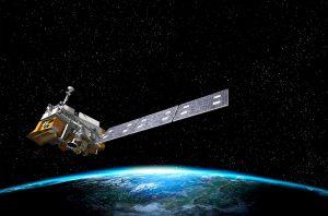
Did you know that 95% of the data used in weather forecasting models comes from satellites? NOAA’s Satellite Service operates the Nation’s weather satellites around the clock, 365 days a year. The next generation of these satellites are being built and prepared for launch by NOAA and NASA. With information from our satellites, airlines can get back to the skies more quickly after foggy conditions, farmers learn when and how to plant crops for better harvests, and ships can navigate a course around dangerous seas or ice. And you know whether to bring an umbrella or sunscreen for your day outside! Join engineer Tim Walsh as he explains what makes the spacecraft orbits for earth-observing satellites special, what it takes to build and launch a spacecraft, and what the future might bring!
Resources to access at home:
Meet JPSS, a pair of Earth-orbiting satellites that give scientists data to predict the weather and climate! JPSS measures water, clouds, wind, temperature and air pressure – which all affect our daily weather. Using JPSS data, scientists can predict and provide warnings for hurricanes, tornadoes and blizzards. JPSS also measures droughts, forest fires, air and water quality, and the health of our ozone layer. There are many ways you can find JPSS in Your Community!
Activities and Resources
» Meet JPSS Comic
» JPSS Coloring Page
» JPSS Detects Greenhouse Gases and Aerosols: Build a Molecule Activity
» JPSS Understanding Infrared Light Activity
» JPSS How to Measure Snow Activity
Videos
» NOAA-20 satellite orbit with Suomi NPP and JPSS-2: See how a polar orbit works.
» JPSS Proving Grounds: Watch and learn about the human impact of weather data.
» 5 Things that Changed Weather Forecasting Forever
» Our Eyes in the Sky: Watch how satellites have improved hurricane forecasting
» Satellite and Weather Videos for Kids: https://goes-r.gov/multimedia/
» Videos used during the webinar:
Polar Orbit Video
NOAA-20 Satellite Launch and Stages Video
Small Satellite Video