
Search results for: cheap%20roundtrip%20airline%20tickets%20colorado%20springs%20to%20tampa%20dec%2015%20to%20jan%203%20phone%20number%201-800-299-7264
Mapping Katama Bay’s Restless Sands
Boaters on Martha’s Vineyard know navigational maps of Katama Bay become obsolete very quickly. Why do the sands at the bottom of the Bay shift so much and so often? Katama Bay has two inlets. Water pours in from Vineyard Sound through Edgartown Channel, and from the Atlantic Ocean through Katama Inlet. The size and…
Read MoreAquaculture Reports Highlight Economic Impact Study of Shellfish Industry, Demand for Alternative Species
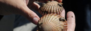
Three new reports regarding shellfish aquaculture in Massachusetts are now available, including an economic impact study of the industry in the commonwealth, a research study into the demand for alternative species of shellfish among wholesalers, and results of a project seeking to develop improved technologies for seed production of the razor clam. The reports can…
Read MoreWHOI-Q-98-002 Sea Grant Making the Most o
WHOI-Q-98-002 Sea Grant Making the Most o
Read MoreWHOI-W-91-001 WHOI U.S. Strategies for Coo
WHOI-W-91-001 WHOI U.S. Strategies for Coo
Read MoreWHOI-R-98-008 Hanlon, R.T. Mating Systems
WHOI-R-98-008 Hanlon, R.T. Mating Systems
Read MoreWHOI-R-87-003 Yossi Mart & David A. Ro
WHOI-R-87-003 Yossi Mart & David A. Ro
Read MoreWHOI-R-82-026 Mann, Roger The Season
WHOI-R-82-026 Mann, Roger The Season
Read MoreWHOI-R-81-015 Finn, D.P. Ocean Disposal o
WHOI-R-81-015 Finn, D.P. Ocean Disposal o
Read MoreWHOI-E-96-002 WHOI Teacher Packet
WHOI-E-96-002 WHOI Teacher Packet
Read MoreWHOI-E-96-001 Crago, T.I. Marine Science Car
WHOI-E-96-001 Crago, T.I. Marine Science Car
Read More