Search results for: Delta Airlines 1800-299-7264 Official Site Customer Service
Multiattribute Analysis and the Concept of Optimum Yield
Multiattribute Analysis and the Concept of Optimum Yield Healey, M.C. Can. J. Fish. Aquat. Sci., Vol. 41, pp. 1393-1406, 1984 WHOI-R-84-014
Read MoreUpdate on River Herring Network
Update on River Herring Network Dec. 2017 — Each spring river herring come from the ocean and swim, or “run” up rivers to spawn in ponds and slow sections of rivers. Each fall, Massachusetts river herring wardens gather together to talk about their favorite fish and discuss ways to preserve it. For centuries, people used…
Read MoreFunding & Fellowships
Research Funding Sea Grant provides a variety of funding opportunities based on its work in four focus areas: Healthy Coastal Ecosystems, Sustainable Fisheries and Aquaculture, Resilient Coastal Communities and Economies, and Environmental Literacy and Workforce Development. National Sea Grant funding opportunities also include National Strategic Investments, for example in aquaculture, and other special projects. Research…
Read MoreThe Louisiana Response to Land Subsidence and Coastal Erosion
The Louisiana Response to Land Subsidence and Coastal Erosion Silva, M. and M. Meo Ocean Engineering and the Environment, Conference Record, Nov. 12-14, 1985, San Diego, California, pp. 594-599, 1985 WHOI-R-85-008
Read MoreCoastal Conference Series Spotlights Nantucket
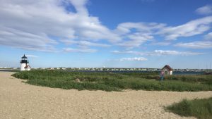
More than 100 people attended the second biennial Nantucket Coastal Conference at the Atheneum on June 26, 2019, to hear about the coastal issues that impact Nantucket and the approaches government, industry and non-profit organizations take in addressing them. Fifth in a series of conferences that started in 2013 and alternate between Martha’s Vineyard and Nantucket,…
Read MoreTeacher Workshop November 2003
Teacher Workshop November 2003 “Right Whale Ecology at the Intersection of Science, Technology, and Conservation” Dr. Mark Baumgartner is an Assistant Scientist in the Biology department of Woods Hole Oceanographic Institution. He studies the foraging behavior and ecology of whales, and the formation and location of the patches of plankton that whales feed on. In this…
Read MoreWHOI-W-05-001 Whitlach, B. International Inv
WHOI-W-05-001 Whitlach, B. International Inv
Read More2004-2006 Projects
Environmental Contaminants and Fish Reproduction Not if, but how? That is the question WHOI postdoctoral investigator Joanna Wilson is asking about how certain environmental contaminants effect marine and freshwater fish reproduction. By applying new research tools—advanced mass spectrometry and proteomics—Wilson and her former graduate advisor, John Stegeman, a WHOI senior scientist, will measure proteins associated…
Read MoreSea Grant Two if by Sea Vol. 8 No. 2 A joint n
Sea Grant Two if by Sea Vol. 8 No. 2 A joint n
Read More2017 NCC
Nantucket Coastal Conference June 6, 2017 Nantucket Atheneum Great Hall, Nantucket, Mass. Keynote Coastal Change Rob Thieler, USGS –Woods Hole, Center Director Coastal Erosion Shifting Sands and the Shorelines of Nantucket Andrew Ashton, Woods Hole Oceanographic Institution (WHOI) Sconset Geotube Update Maria Hartnett, Epsilon Associates; Twenty-three Years of Monitoring Sciasconset, MA Mitch Buck, Woods Hole…
Read More