Search results for: ❤️ Dating für mich: www.Dating4Me.site ❤️ Costaki Economopoulos Dating
WHOI-Q-05-002 Portfolio-Fisheries and Aqua
WHOI-Q-05-002 Portfolio-Fisheries and Aqua
Read More2004-2006 Projects
Fish Otoliths Contain Clues to Larval Distribution Mystery How do you track a moving target? It depends on the size of the target. WHOI fish ecologist Simon Thorrold and research associate Jennifer FitzGerald are taking aim at a very small target: larval Atlantic cod (Gadus morhua). Like most marine fish, cod have a pelagic larval phase,…
Read MoreHelping Communities Lower the Cost of Flood Insurance
Helping Communities Lower the Cost of Flood Insurance March 2018 — Three years ago, Woods Hole Sea Grant and its outreach partner the Cape Cod Cooperative Extension developed a first-of-its-kind program for coordinating regional flood insurance and promoting flood resilience in coastal communities. That program is now serving as a model for others across the…
Read MoreMarine Debris
Marine Debris Marine debris is a global problem that injures and kills marine animals, threatens to navigational safety, and poses a human health threat. WHOI Sea Grant is dedicated to the reduction of marine debris, regionally and globally. We are actively involved in the mitigation of marine debris in our environment by funding research into…
Read MoreHistoric Shipwreck Management: Meeting of Experts II
Historic Shipwreck Management: Meeting of Experts II Hoagland, P. 51 pp., 1993, $3.00 WHOI-T-93-002
Read MoreWHOI-T-94-001 Howes, B.L. Falmouth Pond W
WHOI-T-94-001 Howes, B.L. Falmouth Pond W
Read MoreStudy Provides Measurement of Nitrogen Removal by Local Shellfish
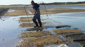
Towns along Cape Cod and the Islands are looking to shellfish not only as tasty culinary treats, but also for help cleaning up waters degraded by excess nitrogen in the region. While nitrogen is essential for all plants and animals, too much nitrogen in ponds and waterways—often caused by fertilizer runoff and septic tanks—can fuel…
Read MoreMapping Katama Bay’s Restless Sands
Boaters on Martha’s Vineyard know navigational maps of Katama Bay become obsolete very quickly. Why do the sands at the bottom of the Bay shift so much and so often? Katama Bay has two inlets. Water pours in from Vineyard Sound through Edgartown Channel, and from the Atlantic Ocean through Katama Inlet. The size and…
Read MoreBenthic Mariculture and Research Rig Developed for Diver Operation
Benthic Mariculture and Research Rig Developed for Diver Operation Hampson, G.R., D.C. Rhoads, and D.W. Clark Diving for Science…1989, Proceedings of the American Academy of Underwater Sciences, Ninth Annual Scientific Diving Symposium, Woods Hole, MA, pp. 113-117, 1989 WHOI-R-89-017
Read MoreCoastal Managers
Coastal Managers Coastal Processes The Coastal Processes Extension agents provide technical assistance to the communities of Barnstable County on a variety of coastal land protection and management issues. This is accomplished through site visits, giving formal and informal presentations to regulatory, business, and community groups, and planning and conducting seminars, workshops, and meetings. The Coastal…
Read More