
Search results for: cheap airline ticket web sites phone number 1-800-299-7264
mportant Changes to the Federal Crop Insurance Program for Quahog Farmers
mportant Changes to the Federal Crop Insurance Program for Quahog Farmers Walton, W. and J. Gallons Marine Extension Bulletin, 4 pp., 2004 WHOI-G-04-003
Read More2004-2006 Projects
Environmental Contaminants and Fish Reproduction Not if, but how? That is the question WHOI postdoctoral investigator Joanna Wilson is asking about how certain environmental contaminants effect marine and freshwater fish reproduction. By applying new research tools—advanced mass spectrometry and proteomics—Wilson and her former graduate advisor, John Stegeman, a WHOI senior scientist, will measure proteins associated…
Read MoreMultiple Genetic Stocks of Longfin Squid Loligo pealeii in the NW Atlantic: Stocks Segregate Inshore in Summer, but Aggregate Offshore in Winter
Multiple Genetic Stocks of Longfin Squid Loligo pealeii in the NW Atlantic: Stocks Segregate Inshore in Summer, but Aggregate Offshore in Winter Buresch, K.C., G. Gerlach, and R.T. Hanlon Marine Ecology Progress Series, Vol. 310, pp. 263-270, 2006 WHOI-R-06-002
Read MoreHurricanes
Hurricanes Though it has been 30 years since the last major hurricane struck the Massachusetts coast, hurricanes can be devastating and they can happen here! Be smart and prepare yourself, your family and your home to minimize losses from a hurricane. https://seagrant.whoi.edu/wp-content/uploads/2020/04/Hurricanes_in_New_England.mp4 Preparing for a Hurricane in New England *From Homeowner’s Handbook to Prepare for…
Read MoreWHOI-Q-05-002 Portfolio-Fisheries and Aqua
WHOI-Q-05-002 Portfolio-Fisheries and Aqua
Read MoreMapping Katama Bay’s Restless Sands
Boaters on Martha’s Vineyard know navigational maps of Katama Bay become obsolete very quickly. Why do the sands at the bottom of the Bay shift so much and so often? Katama Bay has two inlets. Water pours in from Vineyard Sound through Edgartown Channel, and from the Atlantic Ocean through Katama Inlet. The size and…
Read MoreTechnology Enables Better HAB Monitoring and Mapping
Technology Enables Better HAB Monitoring and Mapping The project’s sampling plan for the Nauset area of Cape Cod. Sept. 2018 — Nauset Marsh in Eastham, Mass. on Cape Cod serves as a “natural laboratory” for researchers working to better understand harmful algal blooms (HABs) or red tide. HABs in Nauset are caused by the phytoplankton…
Read MoreSea Grant Two if by Sea Vol. 8 No. 2 A joint n
Sea Grant Two if by Sea Vol. 8 No. 2 A joint n
Read MoreWHOI-R-96-013 Aguilera, A. Immunomagneti
WHOI-R-96-013 Aguilera, A. Immunomagneti
Read MoreClearing the Way for River Herring in Plymouth
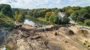
Just a stone’s throw from the Plymouth Rock where the Pilgrim’s first landed in 1620 is the mouth of Town Brook, a river that runs through the center of Plymouth and was once the source of fresh water and food for the Pilgrims. Chief among the fish from the river were herring, whose annual migration…
Read More